Directions: Upon leaving the Harborage Marina proceed out the channel to Marker “S”, then proceed South to Marker “5” (4Nm). At this point take a heading of 210 degrees which will align you with the center of the Sunshine Skyway Bridge. Depending on current flow direction and wind you may have to alter your course to compensate for set and drift to arrive at the center of the bridge. As you approach the bridge be alert for commercial vessels that may approach the bridge from either the Northeast or the West. Again do not impede their passage.
When passing through the bridge stay to the right of center, (5.9Nm), proceed on a heading of 215 degrees which takes you to Marker “70”, Waypoint 27 34.48 N, 82 41.14 W (3.2Nm). Now proceed on a heading of 172 degrees which will take you to Marker “2”, Waypoint 27 32.62 N, 82 40.68 W, which is the channel entrance to the Manatee River (1.9Nm).
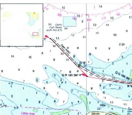
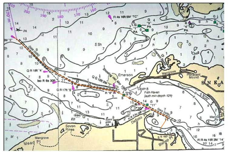
Upon arrival at Marker “2” you will observe the range markers noted on your charts and your boats chart plotter have been removed. At this time DO NOT use your chart plotter to navigate this part of the channel as Day Marker “3” and Day Beacon “4” have been added. Day Marker “3” has been placed in shallow water and at low tide you may ground your boat if you are a beam of this marker within 15 feet.
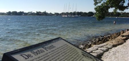
To navigate down this channel upon entry, center Day Beacon “2” on your stern and put Day Beacon “4” on your bow. Keep your boat centered between “2” and “4” as you progress down the channel. Pay attention for leeway and correct as needed. Upon arrival at Marker “4”, center your stern on Marker “4” and look ahead for Day Beacon G “7”. Head straight for G “7” keeping R “4” centered on your stern. Pay attention for leeway and correct as needed. Upon passing G “7” and R “8” follow the markers as observed and arrive at the anchorage as noted. Continue past Marker “12” (2.3Nm) which is located at the point of Desoto Point, and look to starboard for a large two story red brick home with large white columns at the front of the house. When this house is directly abeam turn toward it and proceed into the cove. Continue for (.2Nm) and drop anchor. Depth will be 9 feet. This anchorage is very popular and may be crowded on holidays. If this occurs look for another suitable location within the cove, as long as you stay 200 feet from shore. Avoid the shallow area marked on the chart showing 4 feet.
If the dinghy has been brought along row over to the cross, which can be seen by looking in a southwesterly direction. This area is a small city park in which you will find walking paths which may be enjoyable.
Across the river from Desoto Point is another suitable anchorage. You will anchor in a steady current stream of 2 plus knots. By following standard anchoring procedures and estimating adequate distance from other boats and the shore, you will find this a very nice anchorage with a great view and good protection from a north or easterly wind.
When leaving the Desoto Point anchorage reference the new chart below, and proceed in the reverse of how you entered the anchorage. At Day Beacon “7” will be centered on your stern and your bow will be pointed at Day Beacon “4”. At “4” center your stern on “4” and proceed to “2”. Again pay attention for leeway and correct quickly. Should you want to make Day Beacon “4” a Way Point the Latitude is 27 31’ 582”,Longitude 82 39’ 587”